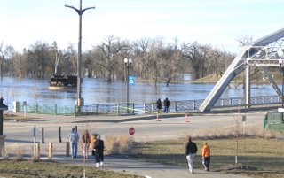
Flood of 06' The Red River Valley is in it's flood stage this time of year. The river here in Grand Forks is around 48 feet now. Not quiet like the flood of 97', but still impressive. The river made it to an all time high of 54 feet in 1997. The dikes have since been raised to 60 feet, and are stonger than ever. So that means everyone heads down to the river to see what's happening. Including the Dingle blogger and I. We went on a little ride tonight and took a few pictures of the spectacle that is the Red River of the North. Enjoy : )
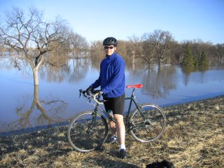
The Dingle blogger on the Lincoln Park dike striking a pose. Nice Surly Cross-Check!
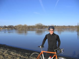
The mighty Poprad with the Mighty Red River in the background. The river is usually on the other side of those trees in the background.
The point bridge was closed due to water running over it on Sunday night. The stink factory is in the background. Otherwise known as the beet plant.

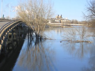
The new floodwall was erected, closing off the Sorlie Bridge on Demers Ave. Only one bridge left between Grand Forks and East Grand Forks. That won't be closed unless the river goes above 50 feet.

The Sorlie Bridge with water bubbling under the girders.
On the left side of this picture is what's left of the old railroad bridge that was torn down after the flood of 97'. This is the center pier that the bridge would pivot on to let steamboats through back in the day. Pretty amazing to think that was possible back then.
I'll try to post some more tomorrow.
In other news Nathan, a crack mechanic at The Ski and Bike Shop, had an Ultimate Fight on Saturday night. I heard it was intense. Unfortunely he fell victim to a choke hold once again. That's okay though. It takes some big ones to get into a mixed martial arts fight with a guy who has a pay per view fight coming up. Keep your chin held high my friend. Or better yet keep it tucked in to defend those choke holds : )
Later


10 comments:
Nice pics Vino. I thought I'd seen it all, but then I see a photo of Andy in lycra. :)
When is the river supposed to crest? And how high?
For his next fight, Nathan should smear KY Liquid all over his neck.
Simmons, I know I will see you soon enough, and you had better be the one watching your neck, because for round four (and oh yes there will be round four) I plan to put you in the choke you give me so much crap about bringing my record against you 4-0; yes folks
4-0.
It's already been broughten!! :)
Thanks for sending your flood waters southward. Are singletrack is now under water.
:-(
That's impossible! The mighty Red River flows north...into Lake Winnipeg.
;)
That's true. It flows up to Paddy H's neighborhood. Sorry Patrick :)
The Red River, one of several by that name, is a North American river. It flows northward through the Red River Valley, forming much of the border between the U.S. states Minnesota and North Dakota, and then flowing into Manitoba, Canada. Measured from the Sheyenne River, it is 877 km long, falling 70 m on its trip towards Lake Winnipeg, spreading into the vast deltaic wetland known as Netley Marsh. It was a key river in the early settlement of Canada, notably being home to the Red River Colony that later became Winnipeg.
In the United States it is called the Red River of the North, to distinguish it from another Red River (a tributary of the Mississippi River that forms part of the border between Texas and Oklahoma).
It is formed at Wahpeton, North Dakota and Breckenridge, Minnesota by the confluence of the Bois de Sioux and Otter Tail rivers.
Looks like it's time for a little urban assalt. Jump....jump.....Splash.
wanna buy a water trike????
If you ride it down here :)
Post a Comment